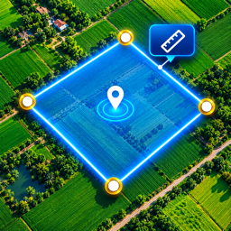
Measure any field, plot or distance with GPS.
Walk the boundary or tap the corners on a satellite map and get area and perimeter instantly, in the unit you prefer. Save, convert and share. No account needed.
Fast, simple and accurate enough for real use
Everything you need to size up land, right on your phone.
Area & perimeter
Tap points on the map or walk around the plot. Undo, redo and edit until the shape is exact.
Distance
Measure straight or multi-point distance between places.
Satellite maps
Satellite, hybrid, street and terrain map views.
Save your fields
Save fields and distances with names and notes. Everything stays on your phone.
Export & share
Share as PDF, KML, JSON, picture or text.
Private by design
No account, no ads, no tracking. Your measurements stay on your device.
Use the units you know
Switch any time, with a built-in converter.
More than a measuring tape
A small toolbox for the field.
Coordinates
See and copy your latitude and longitude.
Compass & direction
Always know which way you are facing.
Altitude
Check your elevation at any spot.
Speedometer
Live speed from GPS while you move.
Spirit level
Check if a surface is level.
GPS timestamp camera
Add date, time and coordinates to a photo.
Built for real use
Farmers & landowners
Check plot size quickly.
Buyers & agents
Get a good estimate before you visit.
Surveyors & builders
Rough measurements on site.
Outdoor lovers
Hikers and runners tracking distance.
Many languages
Use LandMate in your language.
No sign-in
Open the app and start measuring.
Start free. Go Premium when you need more.
Premium is an optional auto-renewing subscription.
Everything to get started
- Measure area and distance
- Up to 10 points per measurement
- Save up to 3 measurements
LandMate Premium
- Unlock extra tools and features
- More points and more saved fields
- Free trial may be available
LandMate: GPS Area Measure
GPS accuracy depends on your device, signal and surroundings. Results are good estimates, not a replacement for a licensed land survey.
Get support